
IELTS Writing Task 1 Maps Strategy: Overview, Changes and Location Language
Write IELTS Academic Task 1 map reports with a clear overview, before-and-after language, precise location verbs and an original worked model.
What a map task requires
Academic Task 1 maps show how a place changed over time, compare two sites, or present a current layout and a proposed redesign. You need at least 150 words, a factual tone and a clear overview. Unlike a chart, a map usually has no numbers to select, so Task Achievement depends on identifying the most important spatial changes and grouping them logically.
Your response still needs the standard structure: introduction, overview and two detail paragraphs. Do not explain why development happened unless the diagram provides that information. Describe visible change, not imagined causes or opinions.
| Map type | Overview focus | Main tense |
|---|---|---|
| Past versus present | Development, removal and unchanged areas | Past and present perfect or present |
| Two past years | Direction and scale of change | Past simple |
| Current versus proposed | Planned additions and reorganisation | Present plus future or passive proposal |
| Two locations | Major similarities and spatial contrasts | Present simple |
Read the map and group the changes
Spend two to three minutes orienting yourself. Find the compass, coastline, roads and fixed reference points. Mark additions with a plus, removals with a cross and unchanged features with a circle. Then group changes by area, such as north and south, or by a coherent development story, such as tourism facilities and transport.
- 1Confirm time and directionRead both labels and find north or another stable anchor before deciding tense.
- 2Mark the big changesIdentify what was built, removed, expanded, relocated or left unchanged.
- 3Choose two groupsDivide the map spatially or functionally so each body paragraph has a clear route.
- 4Draft the overviewState the overall transformation and one major contrast, without minor locations.
- 5Trace each body paragraphMove systematically across one area before switching to the next.
- Mention a feature that remained unchanged when it helps define the scale of development.
- Group connected additions, such as accommodation, paths and a reception building.
- Avoid jumping north, south, north again, which weakens cohesion.
- Check whether a feature was replaced by another or merely built beside it.
Before-and-after and location language
Precise map language combines a change verb with a location anchor. Instead of writing there was a hotel, write a hotel was constructed on the western side of the island, beside the new reception building. Passive voice is common because the feature and its change matter more than who completed the work.
| Function | Useful language | Mini-example |
|---|---|---|
| Addition | was constructed, was introduced, was added | A pier was added to the southern coast. |
| Removal | was demolished, was cleared, disappeared | The storage hut was demolished. |
| Replacement | was replaced by, gave way to | The footpath was replaced by a paved road. |
| Expansion | was extended, doubled in size, spread eastward | The residential area was extended northward. |
| Location | to the north of, adjacent to, between, along | The cafe stands between reception and the beach. |
| No change | remained intact, was left unchanged | The eastern beach remained unchanged. |
Hard to visualise
Vague
There were new buildings and a road.
- •No location
- •No relationship
- •No sense of sequence
Map-led
Precise
Two accommodation clusters were built west and east of reception, and a vehicle track linked the central complex with the southern pier.
- •Anchored locations
- •Grouped features
- •Clear transport link
Worked island map
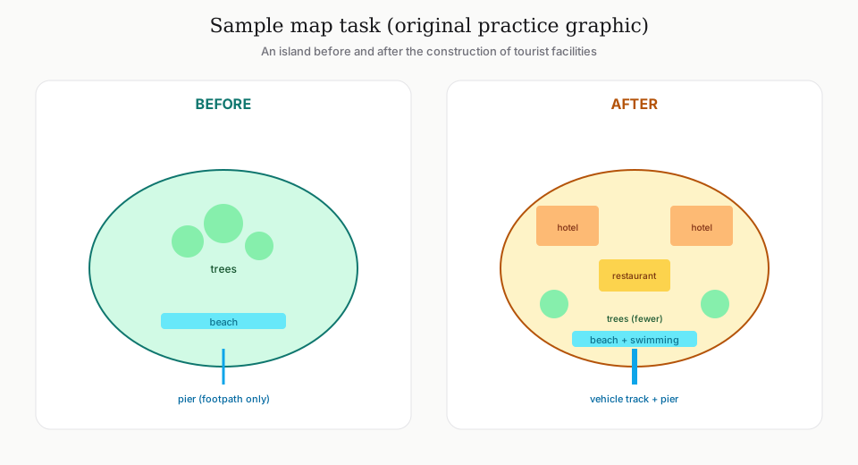
The original practice graphic below shows a small island before and after tourism development. First, identify the dominant transformation: an undeveloped island gains visitor accommodation and transport while the natural shoreline largely remains. Then divide details into the central and western visitor facilities, followed by the southern access and eastern side.
Short model overview and body paragraph
Model overview: Overall, the island was transformed from an undeveloped natural area into a small tourist resort. The most substantial changes were the construction of accommodation and visitor services in the centre and west, together with a new access pier in the south, while the eastern beach and much of the coastline remained intact.
Model body paragraph: In the developed plan, two groups of accommodation huts occupy the western and central parts of the island, with footpaths connecting them to a reception building near the centre. A restaurant was constructed immediately to the north of reception, while a vehicle track runs south from these facilities to a newly built pier. By contrast, the eastern end was left largely unchanged, and swimming is provided for at the beach on the western coast.
| Model choice | Why it works |
|---|---|
| transformed from... into | Summarises the overall before-and-after relationship |
| most substantial changes | Signals selection rather than listing |
| immediately to the north | Places one feature relative to another |
| By contrast | Moves cleanly to the unchanged area |
Common map-report mistakes
Many weak reports list every symbol in no clear order, omit the overview, or use inaccurate verbs. A road that appears in the second map was constructed, not increased. A building that moves location was relocated, not improved. Precision comes from matching the verb to the visible relationship.
- Writing a tour of the first map and then a separate tour of the second, with few direct comparisons.
- Using north and south without checking whether a compass is shown.
- Inventing benefits, reasons or opinions not visible in the diagrams.
- Repeating located in every sentence instead of using beside, opposite, along and between.
- Describing every tree while missing the dominant transformation.
- Using future certainty for a proposed plan instead of is planned, is proposed or will be built.
Practice plan and frequently asked questions
Rotate past-present, proposed and two-location maps. For each one, spend three minutes planning and twenty minutes total. After feedback, rewrite only the overview and one body paragraph so you practise selection without repeatedly producing full responses.
Do map tasks need a conclusion?+
No separate conclusion is required. A clear overview already performs the big-picture function.
Should I describe every feature?+
No. Cover the major changes and enough precise details to support them. Group minor features when possible.
Can I use left and right?+
Compass directions or map-relative locations are usually clearer. Left and right can be ambiguous unless the orientation is fixed.
Which tense should I use?+
Follow the dates and labels. Past maps need past tense, current maps present tense, and proposals need appropriate future or passive planning language.